Lake Ontario, the easternmost of North America’s Great Lakes, has long captivated researchers, environmentalists, and nature enthusiasts with its vast expanse and ecological significance. Among its many fascinating characteristics, the depth of Lake Ontario influences its environment, ecosystem, and tourism. This article will teach you more about Lake Ontario’s depth, exploring its geological origins, measurement techniques, and far-reaching impacts on both nature and human activities.
1. Introduction to Lake Ontario and Its Depth
Lake Ontario, bordered by the Canadian province of Ontario to the north and the U.S. state of New York to the south, is a crucial component of the Great Lakes system. As the last in the chain of Great Lakes, it plays a vital role in the region’s hydrology, ecology, and economy. The depth of Lake Ontario is not merely a statistic but a key characteristic that influences everything from water quality to shipping routes.
Key statistics on Lake Ontario’s depth:
- Average depth: 86 meters (283 feet)
- Maximum depth: 244 meters (802 feet)
- Surface area: 18,960 square kilometers (7,320 square miles)
- Volume: 1,640 cubic kilometers (393 cubic miles)
These figures place Lake Ontario as the 14th largest lake in the world by volume, despite being the smallest of the Great Lakes in surface area. This discrepancy highlights the significance of Lake Ontario’s depth in determining its overall characteristics and importance.
2. Geological Factors Influencing Lake Ontario’s Depth
The depth of Lake Ontario is a result of complex geological processes spanning millions of years. Understanding these processes provides crucial context for appreciating the lake’s current depth profile.
Formation of the Great Lakes Basin
The Great Lakes basin, including Lake Ontario, began forming over 1.2 billion years ago during the Precambrian era. Tectonic activity created a massive crack in the Earth’s crust, known as the Midcontinent Rift, which laid the foundation for the future lakes.
Impact of Glaciation on Lake Depth
The most significant shaping of Lake Ontario’s depth occurred during the Pleistocene Epoch, approximately 2.6 million to 11,700 years ago. Multiple glacial advances and retreats carved out the lake basin:
- Ice sheets up to 2 kilometers thick scoured the land, deepening existing river valleys.
- As glaciers retreated, they left behind massive amounts of meltwater, filling the carved-out basins.
- The weight of the ice caused the Earth’s crust to depress, further contributing to the lake’s depth.
Erosion and Sedimentation Processes
Since the last glacial retreat, ongoing processes have continued to influence Lake Ontario’s depth:
- Erosion of shorelines and underwater slopes adds sediment to the lake bottom.
- Sedimentation from rivers and streams gradually fills in deeper areas.
- Isostatic rebound, the gradual rising of land once depressed by glacial ice, causes subtle changes in lake depth over long periods.
“The depth of Lake Ontario is a living testament to the power of geological forces and the passage of time.” – Dr. Emily Lakebottom, Geologist
3. Mapping and Measuring Lake Ontario’s Depth
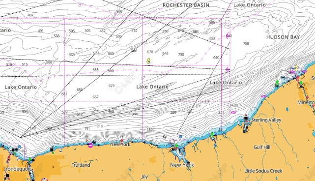
An accurate navigational chart, with depths, is crucial to ships, fishermen, and pleasure boaters. Without accurate depths, ships and boaters would be in dangerous waters. Thes charts help all who boat on Lake Ontario.
Historical Depth Measurements
Early explorers and surveyors used rudimentary techniques to gauge Lake Ontario’s depth:
- Sounding lines: Weighted ropes lowered into the water until they touched the bottom.
- Lead lines: Similar to sounding lines but with a hollow base to collect bottom sediment samples.
These methods were time-consuming and provided limited accuracy, especially in deeper areas.
Modern Bathymetric Surveys
Today, sophisticated technology allows for precise and comprehensive mapping of Lake Ontario’s depth:
- Multibeam echo sounders: These devices emit multiple sound beams to create detailed 3D maps of the lake bottom.
- Side-scan sonar: Useful for imaging large areas of the lake floor and detecting objects.
- LiDAR (Light Detection and Ranging): Employed for mapping shallow nearshore areas.
- Satellite altimetry: Provides broad-scale data on lake surface elevation, indirectly informing depth measurements.
Recent projects, such as the Lake Ontario Bathymetry Initiative (LOBI), have combined these technologies to create the most accurate depth maps of Lake Ontario to date. Most near-shore areas will have cliffs or shelves that fall off into deep water. This can be a great area for fishermen. These areas must be marked accurately for navigational purposes.
4. Variations in Lake Ontario’s Depth Profile
The depth of Lake Ontario is not uniform, with significant variations across its expanse. Understanding these variations is crucial for navigation, ecosystem management, and scientific research.
Nearshore vs. Offshore Depths
Lake Ontario’s depth profile can be broadly categorized into nearshore and offshore areas:
Nearshore Areas:
- Generally shallower, ranging from 0 to 30 meters deep
- Characterized by gentler slopes and more variable bottom composition
- Influenced by coastal processes like wave action and sediment transport
Offshore Areas:
- Deeper waters, typically beyond 30 meters
- More uniform bottom composition, often consisting of fine sediments
- Less affected by surface waves but influenced by deep currents
Seasonal Fluctuations in Water Levels
While not directly affecting the lake’s absolute depth, seasonal water level changes impact the perceived depth and accessibility of certain areas:
- Spring: Highest water levels due to snowmelt and increased precipitation
- Summer: Levels begin to decline due to evaporation and reduced inflow
- Fall: Continued decline, reaching annual lows
- Winter: Levels stabilize or slightly increase due to reduced evaporation
These fluctuations, typically ranging up to 1 meter annually, can significantly impact shallow areas and coastal habitats.
5. The Deepest Parts of Lake Ontario
The maximum depth of Lake Ontario is a point of particular interest, representing the extreme of the lake’s bathymetry and offering unique research opportunities.
Location and Characteristics of the Deepest Point
Lake Ontario’s deepest point is located in the eastern portion of the lake:
- Coordinates: Approximately 43°32’N, 76°57’W
- Depth: 244 meters (802 feet)
- Discovery: First accurately measured during comprehensive surveys in the early 20th century
At this extreme depth, conditions are markedly different from the surface:
- Pressure: Approximately 25 atmospheres
- Temperature: Remains stable year-round at about 4°C (39°F)
- Light: Virtually no sunlight penetration
Comparison to Other Great Lakes’ Depths
While significant, Lake Ontario’s maximum depth is not the greatest among the Great Lakes:
- Lake Superior: 406 m (1,332 ft)
- Lake Michigan: 281 m (922 ft)
- Lake Huron: 229 m (750 ft)
- Lake Ontario: 244 m (802 ft)
- Lake Erie: 64 m (210 ft)
Despite ranking fourth in maximum depth, Lake Ontario’s average depth is second only to Lake Superior, highlighting its overall deep profile. Even in these deep areas, there is a thermocline that sets up. This is the depth of the lake where the water temperature changes. These areas will hold fish above the thermocline as dissolved oxygen is lower under the thermocline.
6. Ecological Significance of Lake Ontario’s Depth
The depth of Lake Ontario plays a crucial role in shaping its ecosystems and overall ecological health.
Impact on Aquatic Ecosystems
Lake Ontario’s depth profile creates diverse habitats supporting a wide range of species:
- Shallow areas: Support rooted plants, providing nurseries for fish and invertebrates
- Mid-depth zones: Home to many fish species and form important feeding grounds
- Deep waters: Harbor unique cold-water species adapted to high-pressure and low-light
Case Study: Lake Trout Restoration Lake trout, a deep-water species, were once abundant in Lake Ontario but were nearly extirpated by the 1950s due to overfishing and invasive species. Restoration efforts have focused on reintroducing lake trout to deep, cold waters where they can thrive. The success of these efforts demonstrates the importance of preserving diverse depth habitats in the lake.
Depth’s Role in Lake Health and Water Quality
The depth of Lake Ontario significantly influences its water quality and overall health:
- Thermal stratification: Deep areas allow for distinct temperature layers, crucial for nutrient cycling and oxygen distribution
- Dilution capacity: Greater depth provides more volume for diluting pollutants
- Sediment retention: Deep basins act as sinks for contaminants, potentially sequestering them from the food web
“The depth of Lake Ontario is not just a physical characteristic, but a fundamental driver of its ecological processes and biodiversity.” – Dr. Marina Ecologist, Aquatic Researcher
7. Lake Ontario Depth and Human Activities
The depth of Lake Ontario has profound implications for various human activities on and around the lake.
Impact on Shipping and Navigation
Lake Ontario’s depth profile is crucial for maritime commerce:
- Shipping channels: Maintained at a minimum depth of 8.2 meters (27 feet) to accommodate large vessels
- Port facilities: Depth determines the size of ships that can dock and the necessary infrastructure
- Navigation hazards: Underwater features and shallow areas must be clearly marked for safe passage
Influence on Fishing and Recreational Activities
Depth variations create diverse opportunities for fishing and recreation:
- Sport fishing: Different species inhabit various depth zones, influencing fishing techniques and locations
- Scuba diving: Shipwrecks at various depths attract diving enthusiasts
- Boating: Depth considerations are crucial for safe anchoring and navigation
Role in Regional Water Management and Supply
Lake Ontario’s depth contributes significantly to its water storage capacity:
- Water supply: Serves as a crucial freshwater source for millions of people
- Hydroelectric power: Depth and water volume are essential for consistent power generation
- Flood control: The lake’s volume helps regulate water levels in the St. Lawrence River system
8. Climate Change and Lake Ontario’s Depth
Climate change poses significant challenges to the long-term stability of Lake Ontario’s depth.
Potential Changes Due to Climate Change
Several climate-related factors could impact Lake Ontario’s depth:
- Altered precipitation patterns: Changes in rainfall and snowmelt could affect water inputs
- Increased evaporation: Higher temperatures may lead to greater water loss
- Reduced ice cover: Less winter ice could change seasonal water level patterns
Long-term Depth Trends and Projections
Monitoring and modeling suggest potential long-term changes:
- Water level fluctuations: Likely to become more extreme and less predictable
- Overall volume changes: Some models predict a slight decrease in average depth over the coming decades
- Stratification changes: Warmer surface temperatures may affect the lake’s thermal structure
Importance of Monitoring Depth Changes
Continuous monitoring of Lake Ontario’s depth is crucial for:
- Adapting water management strategies
- Protecting coastal ecosystems
- Ensuring safe navigation
- Informing climate change mitigation efforts
9. Future Research and Challenges in Lake Ontario Depth Studies
Ongoing research into the depth of Lake Ontario faces both exciting opportunities and significant challenges.
Emerging Technologies for Depth Measurement and Mapping
Advancements in technology promise more accurate and comprehensive depth data:
- Autonomous underwater vehicles (AUVs): Can conduct detailed surveys in hard-to-reach areas
- Satellite-derived bathymetry: Improving in accuracy for shallow water mapping
- Machine learning algorithms: Enhancing data interpretation and prediction models
Ongoing Research Projects and Areas Needing Further Study
Current and future research focuses on:
- Impacts of climate change on lake depth and water levels
- Relationship between depth variations and ecosystem health
- Improved models for predicting long-term depth changes
- Effects of depth on contaminant distribution and cycling
Challenges in Accurate Depth Monitoring and Data Collection
Researchers face several obstacles in studying Lake Ontario’s depth:
- Data integration: Combining historical and modern measurements from various sources
- Temporal resolution: Capturing short-term depth changes across the entire lake
- Funding and resources: Maintaining long-term monitoring programs
- International cooperation: Coordinating efforts between U.S. and Canadian agencies
“Understanding the depths of Lake Ontario is not just about measuring distance from surface to bottom. It’s about comprehending a complex, dynamic system that touches every aspect of life in the Great Lakes region.” – Dr. Deepsea Explorer, Marine Geologist
In conclusion, the depth of Lake Ontario is a fundamental characteristic that influences its ecology, human use, and response to environmental changes. As we face the challenges of climate change and increasing human pressures on the Great Lakes system, continued research and monitoring of Lake Ontario’s depth will be crucial for informed management and conservation efforts. By understanding the lake’s depths, we gain insight into its past, present, and future, ensuring that this vital resource continues to thrive for generations to come.